North Korea has been a frequent topic in news headlines lately – from the country’s threat of a nuclear launch to Google CEO Eric Schmidt’s trip to Pyongyang. However, another story that has been percolating just below the surface for years is just now starting to get attention: Google Maps’ and Google Earth’s revelation of prison camps through satellite imagery.
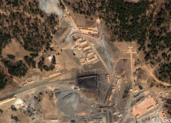
North Korea’s system of political prisons has operated for over fifty years, yet Pyongyang still insists the camps do not exist. The only source of information about the camps has come out through the few who have managed to escape from the camps, until now. On January 18, North Korean Economy Watch announced that a new camp has been identified through the use of Google Earth. Analyst Curtis Melvin, one of those credited with identifying the camp, has said that the perimeter fence stretches nearly thirteen miles. With Google Earth’s satellite images, North Korean Economy Watch has identified two entry points, six possible guard posts, a non-operational coal mine, and a number of accommodation units and office buildings. Human rights activists maintain watch over the camps with this form of constant satellite imagery.
The Committee for Human Rights in North Korea receives imagery and analysis pro bono in a project with DigitalGlobe. DigitalGlobe is a 20-year-old Colorado firm that provides some of Google Earth’s satellite imagery. After companies like DigitalGlobe get the imagery, human rights activists such as Joshua Stanton, a Washington lawyer who runs a blog called One Free Korea, analyze the features of what look like political prisoner camps. Stanton’s work, as well as Melvin’s and Google Earth’s, received acknowledgement in the 2012 edition of “The Hidden Gulag” by the Committee for Human Rights in North Korea.
Although the gulags are not news for these analysts, they are for the rest of the world. Putting the gulags on Google Maps may have gotten a lot of jokes, but it also gave activists a “reason to hope that the world might finally take notice.” With the gulags now visible to the world, U.N. High Commissioner for Human Rights Navanethem Pillay is urging the establishment of an independent international inquiry into the mass atrocity crimes taking place in North Korea. She has “a rare window for meaningful action” because North Korea’s strongest allies, including China, Russia, and Cuba, will finish their terms on the U.N. Human Rights Council before the new session opens next month. This is especially important as other nations, the United States in particular, are focusing on North Korea’s nuclear program and rocket launches. Unfortunately, even though the country’s deplorable human rights situation is now in the open, many leaders fear a human rights discussion would drive Pyongyang away from talks about its weapons programs.
As more and more information comes out about North Korea’s hidden gulags, possibly just from satellite imagery by organizations like Google Earth, it will become harder to turn a blind eye on North Korea’s human rights situation. Google Earth is forcing people to do something about the prison camps in North Korea, whether through negotiations, U.N. actions, or pressure from the international community.
Samantha Peaslee is a 1L at the University of Denver, Sturm College of Law and a staff editor at the Denver Journal of International Law and Policy.